Nau mai ki Waipapa
The Ngāi Tūāhuriri Takiwā (district) begins from the Hurunui River to the north, south to the Hakatere River, inland to the Main Divide and centres on Tuahiwi. Nearby Kaiapoi Pā was established by the first Ngāi Tahu ancestors when they settled in Te Waipounamu. Ōtautahi Christchurch sits within the takiwā of Ngāi Tūāhuriri.
What we now call Ōtautahi was known as a mahinga kai (food gathering) location to Ngāi Tūāhuriri with Kaiapoi as the centre point or principle pā. Once the early settlers arrived, the lands surrounding Christchurch became the principal city for Canterbury and eventually the South Island. Although it is hard to imagine, there was no Ngāi Tahu equivalent to a main pā in the city of Christchurch. Kaiapoi (Tuahiwi) was, and remains, the centre point. And in fact, when Ngāi Tahu elders wrote their letters to Christchurch, they would often use the names ‘Karaitana’, ‘Pūtaringamotu’ or ‘Pūari’ interchangeably as much as ‘Ōtautahi’.
Originally, Ōtautahi was simply a mahinga kai site along the Ōtākaro-Avon River. There were similar mahinga kai sites along the river whether it be Pūari, Ōraka (Horseshoe Lagoon), Pohoareare, or Pūtaringamotu (now commonly known as Riccarton Bush). Ōtautahi became a common reference for Christchurch in the 1930s, popularised by Te Aritaua Pitama who used the name for a Ngāi Tahu social club, despite the objection from his mother.
According to Ngāi Tūāhuriri and Ngāi Tahu archives, the lands from Ōrakipaoa (upper Riccarton) through to Ihutai (Avon River Mouth and Estuary) were all swamp land. Springs and water channels dominated the landscape from the city centre towards Fendalton and Riccarton. Traditional names such as Wairarapa, Wai-whetu, Wai-iti, Kā Wai-maeroa, Wai-utu-utu dominate these suburbs as they all refer to the springs of these tributaries that run into the Ōtākaro River. Kā Wai-maeroa best captures the description of the land. Today, Kā Wai-maeroa is referred to as ‘Waimairi’. Maeroa refers to a small water way or channel and Kā Wai-maeroa simply describes the many springs and waterways that run near the University of Canterbury and Fendalton area.
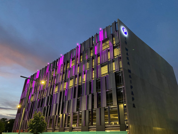
Waipapa refers to a spring along the Ōtākaro-Avon River, towards Carlton Bridge which encompasses the location of this car parking building.
Tū Waka-Waipapa
Tū Waka simply translates as a space to stand your vehicle.
Waipapa refers to a spring along the Ōtākaro-Avon River, towards Carlton Bridge which encompasses the location of this car parking building.
Whetū
The Whetū (star) that adorns the façade is of importance to Ngāi Tūāhuriri. Whetū were used as navigation tools when migrating from Hawaiki, across Te Moana-nui-a-Kiwa (the Pacific Ocean) to Aotearoa and finally to Te Waipounamu. Whetū are tohu (symbols) used not only for voyaging purposes but also to identify the changing of seasons, the months of the year according to the Maramataka (Māori lunar calendar), and the changes in the environment. All of which are necessary tools to understand the growing and harvesting of kai.